|
|
 发表于 2014-7-21 14:28:38
|
显示全部楼层
本帖最后由 lkyfly0531 于 2014-7-22 09:46 编辑
lkyfly0950 发表于 2014-7-18 17:46
贺岁版的就不要试了 阉割了
黑鲨2里面你倒是可以试一试 而且校准惯导之类的都阉割了 另外阉割 ...
最近在深入研究WGS-84系统,发现(对平面地图而言)使用同一个坐标系统,还会有各种各样的投影方式。现在这些各种各样的投影方式就以EPSG代码加以区分:
Coordinate systems are defined using a set of parameters, including the type of projection used (Mercator, Albers etc.), coordinate offset (False Easting, False Northing), the unit of measurement (Metre, Foot etc.), the underlying datum (WGS84, NAD27 etc.) and many more.
Because it’s quite a pain to have to keep quoting this complete set of parameters, every system is commonly referred to by a unique integer code (also called it’s SRID) instead. The set of SRIDs assigned to spatial reference systems in mainstream usage was originally set up by the European Petroleum Survey Group, and they are generally referred to as EPSG codes.
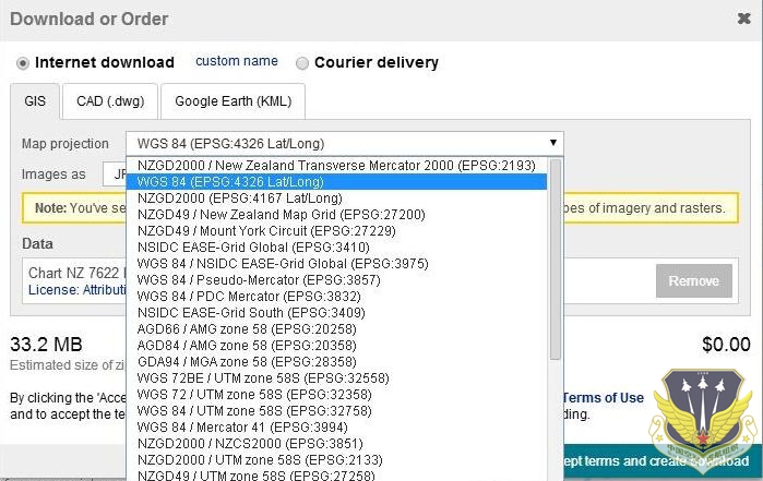
举个例子,比如说你要下载一张地图,那么下载方会给你提供一些投影方式供你选择:

1. 目前最新的WGS-84大地坐标系统是WGS-84 EPSG:4326(4326是WGS-84大地坐标系统的EPSG代码)。谷歌地球使用的就是WGS-84椭球,以经纬度为单位显示大地坐标。
2. 把WGS-84 EPSG:4326投影到2D平面便形成了投影坐标系,根据投影方式的不同产生了不同的EPSG代码:
WGS-84 EPSG:4979, Used by the GPS satellite navigation system
WGS-84 EPSG:3857, Projection used in many popular web mapping applications (Google/Bing/OpenStreetMap/etc). Sometimes known as EPSG:900913
WGS-84 EPSG:3785, Certain Web mapping and visualisation applications
更多信息请参考:http://alastaira.wordpress.com/2 ... ercator-projection/ 以及spatialreference.org |
|
 /1
/1 
 |手机版|小黑屋|中国空军虚航组织(LKYFLY)
( 京ICP备10217415号 )